
by Scott | Aug 12, 2013 | News, Radio Telemetry Pilot Study, Tracking Updates
We did some aerial tracking last Saturday evening. On the way back to Creswell, we detected but did not code a tag somewhere in the vicinity of Marcola Road and 28th St. in Springfield. This weekend, we investigated some of these mystery pings. We drove on 126 and got a strong ping just west of the 42nd St. exit. We circled around and were able to finally code it – as I9 (Gil)! It was strongest from the north side of 126 (42nd St. onramp) and appeared to be coming from the pond north of 126. We also got a faint signal from I20 (Harvey). It was after business hours, so we weren’t able to investigate further. The next day, we started at the southeast end of the pond and moved around the south bank and up the west bank. Our curiosity quickly turned into surprise as we coded not just I9 and I20, but also I12 (Rusty) and I21 (Ole)! We were unable to get to the source of the pings (far northeast corner of the pond) but we are certain they are in there (or on the bank right next to the pond). Four tags in one small area, about five miles from the study section. Two of the fish were small (10”ish) but two weren’t (12”, 16”). Verrrrry interesting! A recovery mission is in the works and the culprits will be identified. Currently, we suspect osprey or eagles; but otters are also active in the area (shown below). You can, as always, see who’s where with Follow Our Fish!...
by Scott | Aug 7, 2013 | News, Radio Telemetry Pilot Study, Tracking Updates
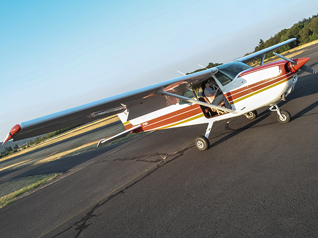
With the summer heat, our fish appear to have settled down for the time being. We’re still tracking about a dozen fish, including Eeyore, Dasha, Chicago, 007, Sonya, Radio, Stanley, Finn, Lenny, Mike S., Waldo, and Wanda. Check who’s where with Follow Our Fish! The rumor on the street is that Wanda and Stanley have met unfortunate demises, but without tag recovery, we can’t be sure. We did get an opportunity to aerial track last week; this time in a Cessna 172 flown by one of the study volunteers. We removed the door and flew low and slow… a fantastic way to spend an...
by Scott | Jun 4, 2013 | Five Year Mark & Recapture Study, News, Tracking Updates
We’ve sent out tracking boats the past few weekends, and little has changed with the status of the tracked fish. We are still unable to locate the following: Nigel, Gil, Rusty, Dixie, Sven, Harvey, Ole, and Lloyd. We do have good fixes on 12 other fish, though no substantial movements have been observed. It is suspected that #022 (Wanda) is dead, and has been for a while. Check out everyone’s locations with Follow Our Fish! The Mark & Recapture Study is progressing nicely, with about 200 fish tagged to date. There have been some remarkable fish caught so far this year, with 495mm, 480mm, and 475mm rainbows receiving tags. For those of you who speak in inches, these are 19-20″ fish. Anglers have also noticed an increase in the number of fish in the 200-300mm (8-12″) class this year. Fewer small fish are being caught (less than 200mm), and more medium fish. This seems to be a nice trend and makes fishing more fun. Get out there while you can – we have about a month left in the...

by Scott | May 13, 2013 | Five Year Mark & Recapture Study, News, Radio Telemetry Pilot Study, Tracking Updates
“Where’d that fish run off to?” is a question we’ve been asking for several weeks now. We located one of the missing fish this past week by reviewing fixed station data provided by the University of Idaho, who operates a series of antenna arrays in the Willamette system. “007” showed up as at Leaburg Dam (RM 40.0) on 3/1/2013; lingering in the area for about 6 hours. We got lucky since our transmitters are only active for 2 days per week – he just happened to be passing the antenna when his transmitter was on. He had previously last been seen on 2/1 at RM 20.8. Our trackers located him this past week (5/10) at RM 23.1 – back in the study section! This means that “007” made a remarkable round trip of at least 36 miles in less than three months! He may well have gone further as we did not pick him up on our telemetry flight on 4/21. We located our other usual suspects this past week in a float from Taylor’s Landing (RM 28.2) to Bellinger (RM 19.0). See who’s where with Follow Our Fish! We kicked off the 4th year of the Mark & Recapture Study on May 1, and early returns from anglers have been good, with several nice rainbow trout caught and lots of action on dry flies. Stay tuned for...

by Scott | Apr 30, 2013 | Five Year Mark & Recapture Study, News
In addition to expanding our reporting for the 2012 season, we’ve completed a comprehensive audit of the first three years of data. Thus, these reports may be slightly different than those from previous years. Lower McKenzie Wild Trout Population Study: 2012 Final Report (PDF, 0.7mb) 2010 – 2012 Distribution of Wild Trout, Aerial Photo & Map (PDF, 14.5mb) 2010 – 2012 Distribution of All Fish, Maps (PDF, 0.3mb) Read more about the Mark & Recapture...

by Scott | Apr 22, 2013 | News, Radio Telemetry Pilot Study, Tracking Updates
We were finally able to schedule a radio-tracking flight for Friday afternoon, but the weather didn’t cooperate and we were rained out. We were able to reschedule to Sunday morning at the crack of dawn – and three of us braved the early hour and lifted off the ground at about 6:30AM. The clouds were low – a solid deck at 1,400’, right at the legal allowable minimum. We figured we’d make it at least to the narrowing of the McKenzieValley at HendricksBridge. We took off, and headed towards the Willamette. I was sitting shotgun, with the window up, arm out the window with the handheld antenna. It wasn’t pretty, but it was effective and didn’t require any special rigging or FAA approvals. Two volunteers, let’s call them ‘volunteer man familiar with telemetry’ and ‘volunteer woman familiar with telemetry’, were in the rear seats. VManFWT had the datasheet and GPS; VWomanFWT had the receiver. We planned that the receiver-holder would call out the tag number and power, and the recorder would scribble down the data. We set the receiver at a high gain of +90 and flew up the McKenzie. We started hearing tags clearly around HaydenBridge, but the receiver did not code any of them. We received many error codes (I1, I999, etc). We continued upriver to Hendricks, where the clouds had socked in the upper valley. We turned around and went downstream, figuring there was no use continuing upstream unless we were able to code fish. We played with the gain, dropping it to +70, and began coding fish on the way downstream near Bellinger. We turned...